Map of the US states
An interactive map of the United States with all 50 states. Turn on state names, two-letter abbreviations, the 50 state capitals, major cities or the four Census regions, and click any state to see its capital, its region and its time zone. Everything on the map is also in the table below, and every version can be printed.
- Northeast
- Midwest
- South
- West
- State capital
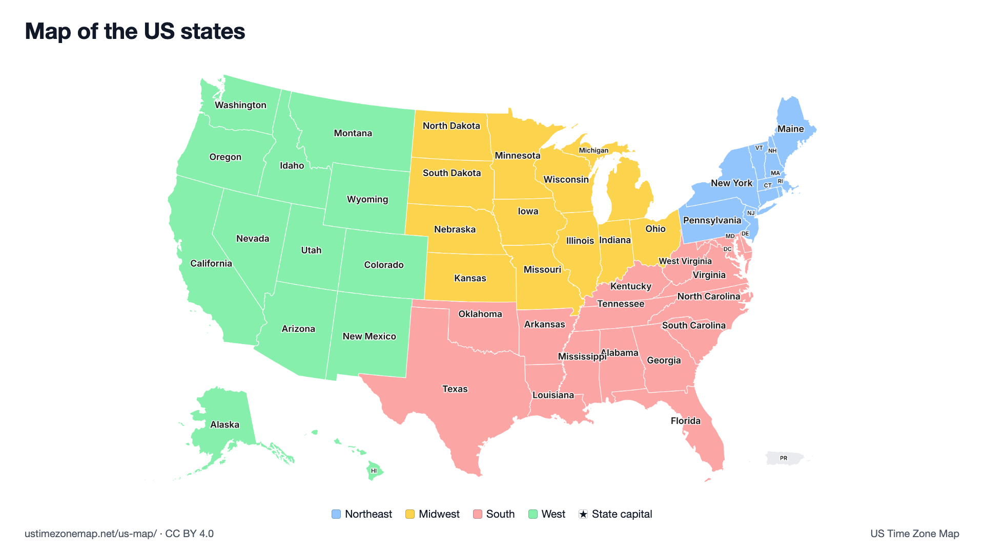
Click or tap a state to see its abbreviation, capital, region and time zone.
The 50 states, their abbreviations and capitals
All 50 states and Washington, D.C., A to Z. Each state links to its time zone map and local time; capitals link to the city's own page where there is one.
| State | Abbreviation | Capital | Region | Time zone |
|---|---|---|---|---|
| Alabama | AL | Montgomery | South | Central Time, statewide |
| Alaska | AK | Juneau | West | Alaska Time |
| Arizona | AZ | Phoenix | West | Mountain Time with no DST |
| Arkansas | AR | Little Rock | South | Central Time |
| California | CA | Sacramento | West | Pacific Time |
| Colorado | CO | Denver | West | Mountain Time |
| Connecticut | CT | Hartford | Northeast | Eastern Time |
| Delaware | DE | Dover | South | Eastern Time |
| District of Columbia | DC | None (federal district) | South | Eastern Time, citywide |
| Florida | FL | Tallahassee | South | Eastern Time |
| Georgia | GA | Atlanta | South | Eastern Time |
| Hawaii | HI | Honolulu | West | Hawaii–Aleutian Time |
| Idaho | ID | Boise | West | Mountain Time |
| Illinois | IL | Springfield | Midwest | Central Time |
| Indiana | IN | Indianapolis | Midwest | Eastern Time |
| Iowa | IA | Des Moines | Midwest | Central Time |
| Kansas | KS | Topeka | Midwest | Central Time |
| Kentucky | KY | Frankfort | South | Eastern Time in the east |
| Louisiana | LA | Baton Rouge | South | Central Time |
| Maine | ME | Augusta | Northeast | Eastern Time |
| Maryland | MD | Annapolis | South | Eastern Time |
| Massachusetts | MA | Boston | Northeast | Eastern Time |
| Michigan | MI | Lansing | Midwest | Eastern Time |
| Minnesota | MN | Saint Paul | Midwest | Central Time |
| Mississippi | MS | Jackson | South | Central Time |
| Missouri | MO | Jefferson City | Midwest | Central Time |
| Montana | MT | Helena | West | Mountain Time |
| Nebraska | NE | Lincoln | Midwest | Central Time |
| Nevada | NV | Carson City | West | Pacific Time |
| New Hampshire | NH | Concord | Northeast | Eastern Time |
| New Jersey | NJ | Trenton | Northeast | Eastern Time |
| New Mexico | NM | Santa Fe | West | Mountain Time |
| New York | NY | Albany | Northeast | Eastern Time |
| North Carolina | NC | Raleigh | South | Eastern Time |
| North Dakota | ND | Bismarck | Midwest | Central Time |
| Ohio | OH | Columbus | Midwest | Eastern Time |
| Oklahoma | OK | Oklahoma City | South | Central Time, statewide |
| Oregon | OR | Salem | West | Pacific Time |
| Pennsylvania | PA | Harrisburg | Northeast | Eastern Time |
| Rhode Island | RI | Providence | Northeast | Eastern Time |
| South Carolina | SC | Columbia | South | Eastern Time |
| South Dakota | SD | Pierre | Midwest | Central Time in the east |
| Tennessee | TN | Nashville | South | Central Time |
| Texas | TX | Austin | South | Central Time |
| Utah | UT | Salt Lake City | West | Mountain Time |
| Vermont | VT | Montpelier | Northeast | Eastern Time |
| Virginia | VA | Richmond | South | Eastern Time |
| Washington | WA | Olympia | West | Pacific Time |
| West Virginia | WV | Charleston | South | Eastern Time |
| Wisconsin | WI | Madison | Midwest | Central Time |
| Wyoming | WY | Cheyenne | West | Mountain Time |
Puerto Rico, shown in the lower right of the map, is a U.S. territory with San Juan as its capital. It is not one of the 50 states and is not in a Census region.
US regions: Northeast, Midwest, South and West
The U.S. Census Bureau sorts the states into four regions. Turn on Region colours on the map to see them.
Northeast (9 states)
Connecticut, Maine, Massachusetts, New Hampshire, New Jersey, New York, Pennsylvania, Rhode Island, Vermont.
Midwest (12 states)
Illinois, Indiana, Iowa, Kansas, Michigan, Minnesota, Missouri, Nebraska, North Dakota, Ohio, South Dakota, Wisconsin.
South (16 states plus D.C.)
Alabama, Arkansas, Delaware, Florida, Georgia, Kentucky, Louisiana, Maryland, Mississippi, North Carolina, Oklahoma, South Carolina, Tennessee, Texas, Virginia, West Virginia.
West (13 states)
Alaska, Arizona, California, Colorado, Hawaii, Idaho, Montana, Nevada, New Mexico, Oregon, Utah, Washington, Wyoming.
The 48 contiguous states, Alaska and Hawaii
48 states share a continuous border on the mainland, from Washington and Maine in the north to Florida and Texas in the south. Alaska borders Canada in the far northwest and Hawaii is an island chain in the Pacific Ocean, so like most US maps this one draws them as insets in the lower left. They are moved and not to scale: Alaska is the largest state by area and would cover much of the map at true size. Rhode Island is the smallest state.
Need the cities too? The US map with cities marks 101 cities and all 50 capitals, with a list by state. For time, the US time zone map colours the same states by time zone and the state time zone directory gives each state's zone and UTC offset.
Printable US maps
Free vector PDFs on US Letter paper, landscape. They print sharp on A4 with “Fit to page”.
- US map with state names: every state named, coloured by region
- US map with capitals: all 50 capitals marked with a star
- US map with cities: major cities and towns named
- Outline of the United States: the national border only, no state lines
- Blank US map: state borders, no names, for quizzes and colouring
- Numbered blank US map: numbered states with an answer key
All sheets, including the time zone maps, are on the printable maps page.
Learn the map
Test yourself with the 50 states quiz, where you click each state on a blank map, then the state capitals quiz, where you match each capital to its state. Thelist of state capitals has every capital with its time zone and coordinates.
Frequently asked questions
How many states are on the US map?
Fifty. The map also shows Washington, D.C., which is a federal district and not a state, and Puerto Rico, a U.S. territory. 48 states are contiguous; Alaska and Hawaii are not, so they appear as insets in the lower left, moved and not to scale.
What are the 4 regions of the United States?
The U.S. Census Bureau groups the states into four regions: the Northeast (9 states), the Midwest (12), the South (16 states plus D.C.) and the West (13). The region colours on this map follow that grouping.
Where do the two-letter state abbreviations come from?
They are the postal codes set by the U.S. Postal Service, such as CA for California and TX for Texas. Turn on Abbreviations above to see them on the map; the table lists all 50 plus DC.
Can I print this map?
Yes. Free printable PDFs of the US map with state names, with capitals, with cities, as a blank map and as an outline are listed on this page. Each is a vector PDF on US Letter paper.
Which state capitals are not the largest city in their state?
Many. Well-known examples are Albany (not New York City), Sacramento (not Los Angeles), Springfield (not Chicago), Tallahassee (not Jacksonville or Miami) and Harrisburg (not Philadelphia). Turn on Capitals to see every capital on the map.
Sources: state shapes from the U.S. Census Bureau via us-atlas; capital locations from the U.S. Census Bureau 2024 Gazetteer; regions from the Census Bureau's “Census Regions and Divisions of the United States”. See data sources.