US map with cities
A map of the United States with 101 cities and all 50 state capitals. Capitals are red stars, other cities are dots, and each dot links to that city's page with its local time and time zone. Turn layers on and off above the map, or click a state for its capital and region. The full list, state by state, is below the map.
- Northeast
- Midwest
- South
- West
- State capital
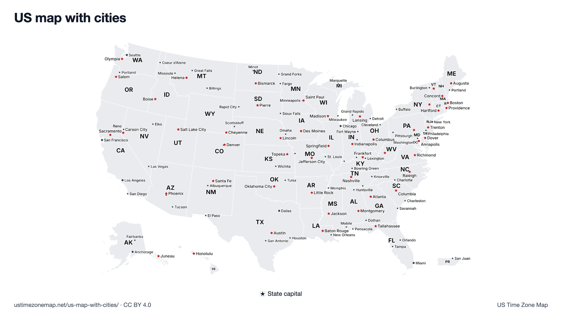
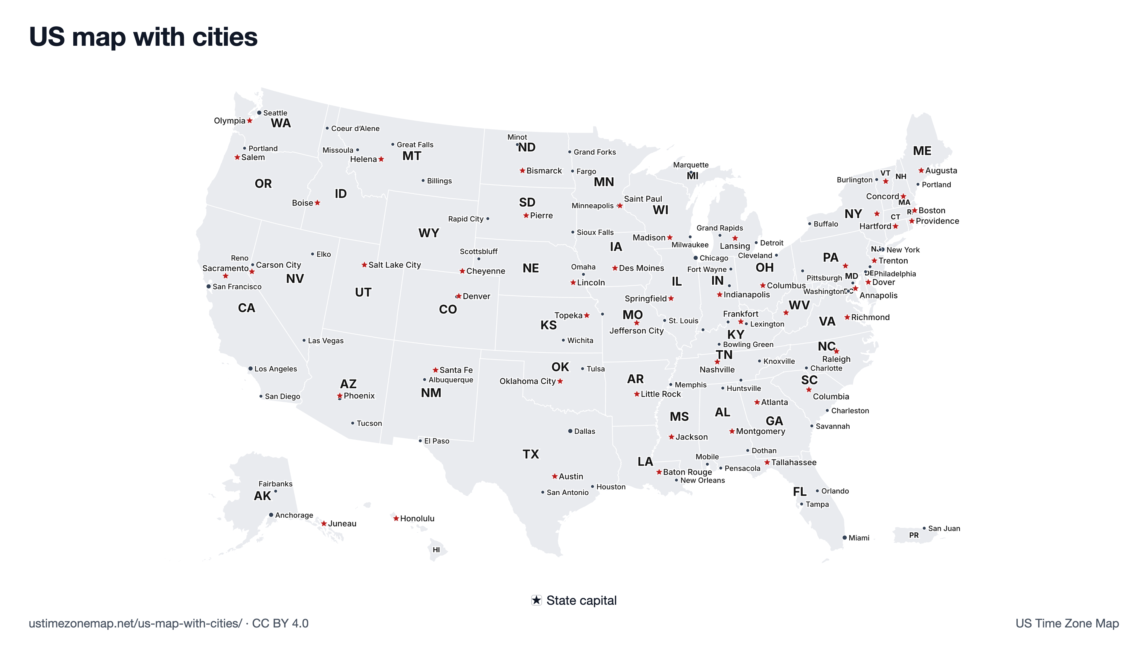
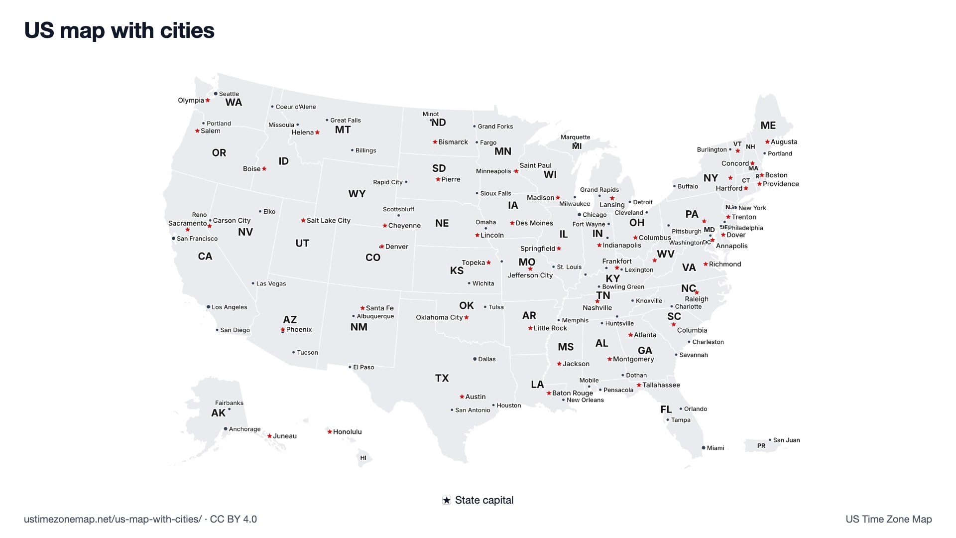
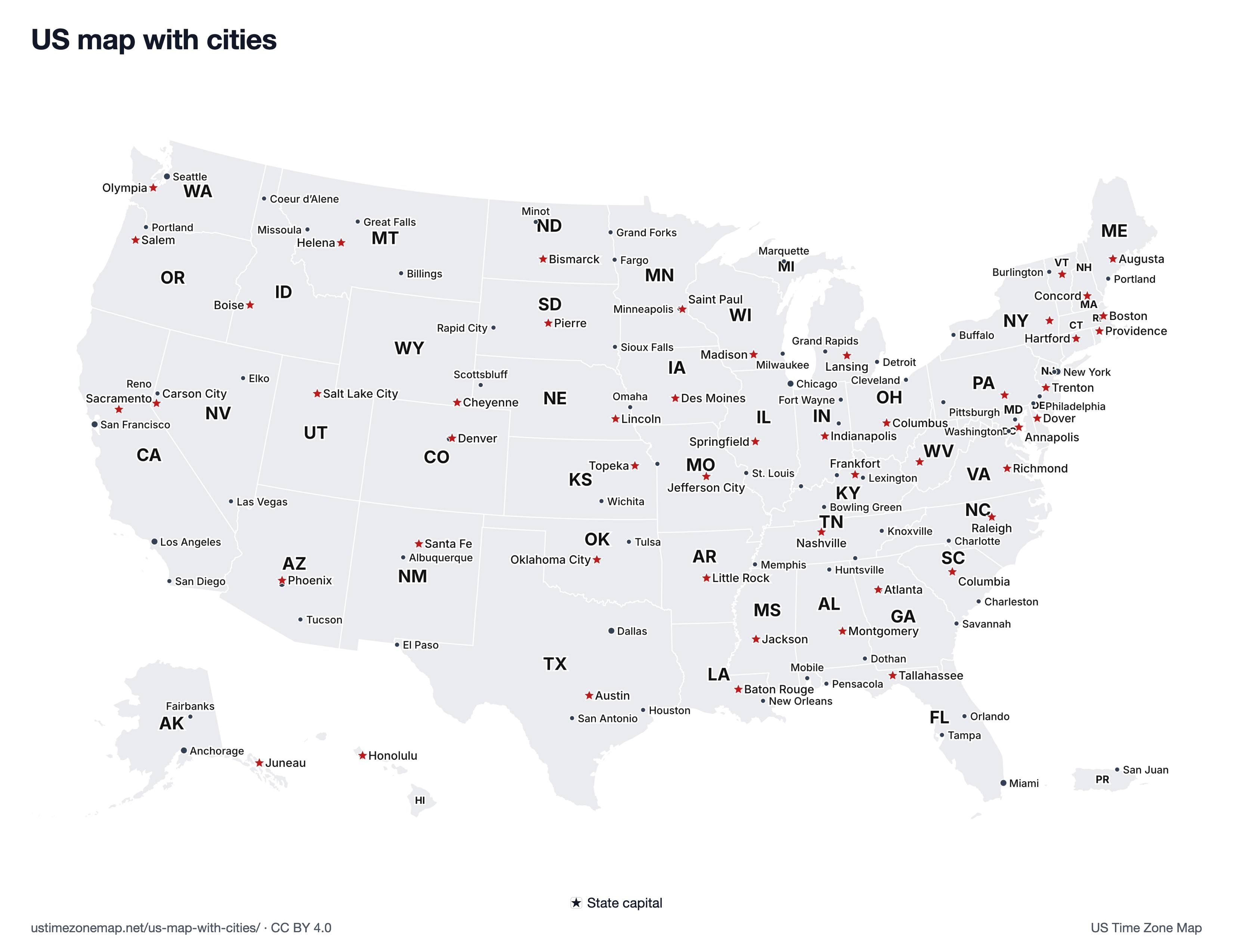
Click or tap a state to see its abbreviation, capital, region and time zone.
Major US cities
The larger metros on the map, each linking to its local time:
- Los Angeles, CA
- San Francisco, CA
- Seattle, WA
- Phoenix, AZ
- Denver, CO
- Dallas, TX
- Chicago, IL
- New York, NY
- Atlanta, GA
- Miami, FL
- Anchorage, AK
- Honolulu, HI
Cities on the map, by state
Every state with its capital (★) and the other cities on the map. State names link to the state's time zone page.
- Alabama (AL)
- ★ Montgomery · Dothan, Huntsville, Mobile
- Alaska (AK)
- ★ Juneau · Anchorage, Fairbanks
- Arizona (AZ)
- ★ Phoenix · Tucson
- Arkansas (AR)
- ★ Little Rock
- California (CA)
- ★ Sacramento · Los Angeles, San Diego, San Francisco
- Colorado (CO)
- ★ Denver
- Connecticut (CT)
- ★ Hartford
- Delaware (DE)
- ★ Dover · Wilmington
- District of Columbia (DC)
- Washington
- Florida (FL)
- ★ Tallahassee · Miami, Orlando, Pensacola, Tampa
- Georgia (GA)
- ★ Atlanta · Savannah
- Hawaii (HI)
- ★ Honolulu
- Idaho (ID)
- ★ Boise · Coeur d’Alene
- Illinois (IL)
- ★ Springfield · Chicago
- Indiana (IN)
- ★ Indianapolis · Evansville, Fort Wayne, Muncie
- Iowa (IA)
- ★ Des Moines
- Kansas (KS)
- ★ Topeka · Wichita
- Kentucky (KY)
- ★ Frankfort · Bowling Green, Lexington, Louisville
- Louisiana (LA)
- ★ Baton Rouge · New Orleans
- Maine (ME)
- ★ Augusta · Portland
- Maryland (MD)
- ★ Annapolis · Baltimore
- Massachusetts (MA)
- ★ Boston
- Michigan (MI)
- ★ Lansing · Detroit, Grand Rapids, Marquette
- Minnesota (MN)
- ★ Saint Paul · Minneapolis
- Mississippi (MS)
- ★ Jackson
- Missouri (MO)
- ★ Jefferson City · Kansas City, St. Louis
- Montana (MT)
- ★ Helena · Billings, Great Falls, Missoula
- Nebraska (NE)
- ★ Lincoln · Omaha, Scottsbluff
- Nevada (NV)
- ★ Carson City · Elko, Las Vegas, Reno
- New Hampshire (NH)
- ★ Concord
- New Jersey (NJ)
- ★ Trenton · Newark
- New Mexico (NM)
- ★ Santa Fe · Albuquerque
- New York (NY)
- ★ Albany · Buffalo, New York
- North Carolina (NC)
- ★ Raleigh · Charlotte
- North Dakota (ND)
- ★ Bismarck · Fargo, Grand Forks, Minot
- Ohio (OH)
- ★ Columbus · Cleveland
- Oklahoma (OK)
- ★ Oklahoma City · Tulsa
- Oregon (OR)
- ★ Salem · Portland
- Pennsylvania (PA)
- ★ Harrisburg · Philadelphia, Pittsburgh
- Puerto Rico (PR)
- ★ San Juan
- Rhode Island (RI)
- ★ Providence
- South Carolina (SC)
- ★ Columbia · Charleston
- South Dakota (SD)
- ★ Pierre · Rapid City, Sioux Falls
- Tennessee (TN)
- ★ Nashville · Chattanooga, Knoxville, Memphis
- Texas (TX)
- ★ Austin · Dallas, El Paso, Houston, San Antonio
- Utah (UT)
- ★ Salt Lake City
- Vermont (VT)
- ★ Montpelier · Burlington
- Virginia (VA)
- ★ Richmond
- Washington (WA)
- ★ Olympia · Seattle
- West Virginia (WV)
- ★ Charleston
- Wisconsin (WI)
- ★ Madison · Milwaukee
- Wyoming (WY)
- ★ Cheyenne
Maps and lists that go with this one
- Map of the US states: names, abbreviations, capitals and regions, with a table of all 50 states.
- US time zone map with cities: the same cities coloured by time zone, with live clocks.
- Printable US map with cities and printable US map with capitals (free PDFs).
- State capitals quiz: match each capital to its state.
Frequently asked questions
Which cities are on this map?
101 cities and towns that have their own local-time page on this site, chosen to cover every state and every US time zone, and all 50 state capitals (several capitals are among those cities). It is not a ranking by population: some large suburbs are left out and some smaller towns are in because they sit near a time zone line.
How do I see only the capitals?
Untick Cities above the map and keep Capitals on. The red stars are the 50 state capitals, placed from the U.S. Census Bureau 2024 Gazetteer.
Is there a printable US map with cities?
Yes. The printable US map with cities is a free vector PDF on US Letter paper that names as many of these cities as fit without overlapping, and there is a separate printable map with the 50 capitals.
Why are Alaska and Hawaii in the corner?
Like most US maps, this one moves Alaska and Hawaii into insets in the lower left so the 48 contiguous states can be drawn larger. They are not to scale.
Sources: city coordinates from this site's city data; capital locations from the U.S. Census Bureau 2024 Gazetteer. See data sources.